Amangu Sovereign State: Northern Coastal Boundaries, Ethnohistory & Customary Science
Primary Field Dispatches, Tindale (1974) Boundaries, Archival Wordlists & Unceded Legal Jurisdiction
The Amangu Sovereign State (historically recorded as Emangu, Amandyo, Merenji, Jing, Ying, and the Champion Bay Tribe) demarcates the northern coastal and sub-coastal territorial jurisdiction of the Bibbullmun Confederation.1 Encompassing the fertile alluvial valleys of the Irwin, Greenough, and Chapman Rivers, the Amangu territory forms a pivotal ecological and legal corridor linking the coastal limestone belt with the mid-west wheatbelt inland plains.2 Traditional Custodians of this northern domain maintained an unbroken continuum of land stewardship, marine reef harvesting, and intensive agricultural engineering across more than 48,000 years of documented living culture.3
1. Ethnohistorical Foundations, Orthography & Tindale (1974) Boundaries
The geographic boundaries and ethnohistorical foundations of the Amangu Sovereign State are established in the foundational cartographic research of anthropologist Norman B. Tindale, as published in his monumental 1974 monograph, Aboriginal Tribes of Australia: Their Terrain, Environmental Controls, Distribution, Limits, and Proper Names (South Australian Museum Collection).4 Tindale demarcated the Amangu country as a distinct coastal and sub-coastal territorial estate spanning approximately 15,000 square kilometers across south-western Australia's mid-west region.5
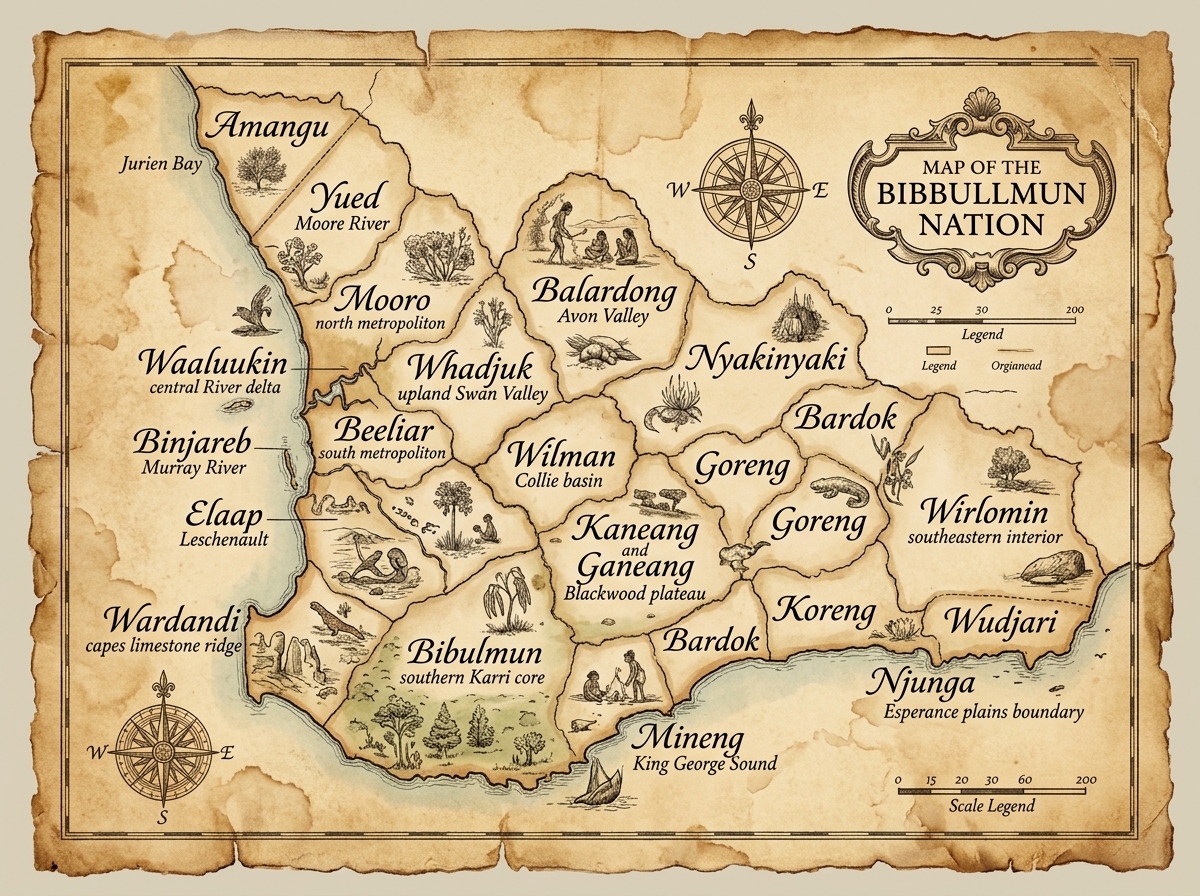
The northern coastal boundary of Amangu jurisdiction is anchored at Champion Bay and the Chapman River, taking in the entire modern Geraldton urban and coastal district. From Champion Bay, the coastal line extends continuously southward along the Indian Ocean shoreline past Dongara, Port Denison, and the mouth of the Greenough River to the Hill River near Jurien and Leeman.6 Inland, Amangu territory stretches eastward across the alluvial valleys of the Irwin River (Irwin Bilya) and Greenough River catchments, taking in the inland townships and agricultural plains of Mullewa, Morawa, Perenjori, and Carnamah.7 To the south, the Amangu territory forms a well-established border north of Moora, interlocking with the territory of the Yued Sovereign State through shared sub-coastal claypan networks and seasonal hunting corridors.8
Linguistically and ethnographically, the ethnonym Amangu (assigned AIATSIS AUSTLANG Code W12) is preserved across multiple 19th-century colonial dispatches.9 Early British observers recorded several dialectical orthographies, including Emangu, Amandyo, Merenji, Jing, Ying, and the regional descriptor Champion Bay Tribe.10 Ethnographer Daisy Bates (National Library of Australia MS 365) recorded extensive notes on the northern frontier of the Bibbullmun nationhood, noting that the Amangu maintained a strict adherence to non-circumcision customary law and 4-skin moiety governance, serving as a vital legal barrier between the southern Bibbullmun confederated states and the circumcising Yamatji groups further north along the Murchison River.11
2. Primary Archival Evidence, Field Vocabularies & Linguistic Analysis
Direct archival evidence documenting the Amangu language and cultural terminology is preserved in two major 19th-century primary field vocabularies.12 The earliest systematic wordlist was compiled by R. J. Foley in 1865 under the title Vocabulary of the Champion Bay Tribe, published in Augustus Oldfield’s landmark volume, Transactions of the Ethnological Society of London (1865).13 Foley’s primary records captured the spoken language of traditional Custodians along Champion Bay, recording key kinship terms, environmental identifiers, and daily vocabulary. Notably, Foley documented the term am-manjo (signifying "man" or "person" within local speech), from which the modern standardized orthography Amangu was codified by subsequent linguists.14
A second vital primary vocabulary was collected in 1886 by Roger Goldsworthy, who served as Colonial Secretary of Western Australia. Goldsworthy’s field survey, titled Irwin and Greenough Rivers Vocabulary, was subsequently published in Edward M. Curr’s monumental compendium, The Australian Race: Its Origin, Languages, Customs, Place of Landing in Australia (1886).15 Goldsworthy’s wordlist verified the continuity of Amangu terminology across the inland river catchments, providing invaluable comparative data on plant harvesting tools, totemic fauna, and parental lineage designations.16
| Term (Foley 1865 / Goldsworthy 1886) | English Meaning | Cultural Science & Context |
|---|---|---|
| ammatha | Father / Paternal Lineage | Patrilineal estate connection and law keeper duty. |
| agootha | Mother / Matriarchal Line | Matriarchal skin group transmission and yam bed custody. |
| yellabidde / kilire | Emu (*Dromaius novaehollandiae*) | Totemic species and sky marker (*Waitj*). |
| wanna | Digging Stick / Harvester | Agricultural tool for wild yam (*Dioscorea hastifolia*) extraction. |
| mini | Stranger / Non-Initiate | Colonial-era designation for uninitiated European settlers. |
| bidi | Trail / Trade Highway | Interstate trade paths for ochre (*Wilgie*) and shell exchange. |
Together, the Foley (1865) and Goldsworthy (1886) vocabularies demonstrate that Amangu was a distinct, highly developed language within the Southwestern Pama-Nyungan family.17 Analysis of these historical texts confirms that terms like wanna (digging stick) and bidi (pathway) shared direct structural cognates with southern Bibbullmun dialects, while parental terms like ammatha and agootha reflected specialized northern kinship nomenclature.18
3. Customary Science, Agricultural Yam Engineering & Six Seasons Migration
Amangu environmental engineering represents one of the most sophisticated pre-contact agricultural systems documented in Western Australia.19 Along the rich alluvial floodplains of the Greenough and Irwin Rivers, Amangu land managers cultivated vast, dense beds of the native wild yam (*Dioscorea hastifolia*).20 Contrary to colonial myths of opportunistic hunter-gatherer existence, historical and ethnobotanical studies by researchers Beth Schultz and Rupert Gerritsen (2008) prove that the Amangu practiced systematic soil cultivation.21 Traditional harvesters used hardened wooden digging sticks (*Wanna*) to turn over and aerate the heavy alluvial soil, selectively harvesting mature tubers while systematically re-planting the growing tops (*heads*) back into loosened earth.22 Combined with periodic low-intensity firing (*Karl*) to clear competing scrub, this intensive horticultural cycle ensured sustainable annual yields capable of supporting large seasonal gatherings.23
Complementing terrestrial agriculture, Amangu customary science incorporated marine engineering along the limestone coast.24 At Champion Bay, Dongara, and Port Denison, Custodians constructed stone fish traps and tidal weirs along intertidal reefs, harvesting marine fish, crayfish, and shellfish.25 Terrestrial flora was similarly managed: the seed pods and sweet edible gum of the Jam tree (*Acacia acuminata*) were harvested and processed into nutrient-rich cakes, while the leaves of the Peppermint tree (*Wonnil*) were steamed to extract anti-bacterial oils for Mabarn medicinal healing.26
Economic activity and social movement were governed by the Six Seasons (*Bonar*) ecological calendar:
- Birak & Bunuru (First & Second Summer): Focus shifted to the ocean coast. Amangu clans congregated around Champion Bay and Port Denison reefs for crayfish diving, stone trap fishing, and coastal waterhole stewardship.27
- Djeran & Makuru (Autumn & Winter): Clans migrated inland along the Irwin and Greenough river corridors. Winter months were spent harvesting wild yams, hunting western grey kangaroos (*Yongka*), and establishing warm winter encampments utilizing limestone cave overhangs.28
- Djilba & Kambarang (Spring): Focus turned to *Acacia* gum processing, wildflower seed collection, and interstate trade along ancient pathways (*Bidi*), exchanging high-grade red ochre (*Wilgie*) from inland quarries for coastal pearl shells and southern stone axes (*Kodj*).29
4. Archaeological Continuum & Yellabidde Cave Overhangs
The antiquity and unbroken continuum of Amangu occupation are substantiated by extensive archaeological investigations across the coastal limestone karst formations of mid-west Western Australia.30 Key among these sites is **Yellabidde Cave**, a major rock shelter located near Leeman in the southern precinct of traditional Amangu country.31 Excavations conducted by multidisciplinary archaeological teams revealed deep, stratified cultural deposits containing hearth charcoal, stone artifacts, and butchered fauna remains dating back more than 23,000 years before present, with lower stratigraphy indicating human presence extending toward 48,000 years.32
The material culture recovered from Yellabidde Cave provides a detailed record of technological adaptation across major climatic shifts, including the Last Glacial Maximum (LGM).33 Stratigraphic layers yield fine-grained quartzite scrapers, backing blades, dolerite hammerstones, and flat anvil stones used for crushing wattle seeds and grinding ochre pigments.34 Faunal analysis demonstrates a consistent diet of emu (*yellabidde* / *kilire*), kangaroo (*yongka*), wallaby, and marine shellfish, demonstrating that Amangu ancestors maintained an integrated coastal-inland foraging and harvesting strategy across deep time.35
Furthermore, rock art panels and stencil art preserved within limestone overhangs along the Greenough River supply vivid visual evidence of Amangu spiritual cosmology and ceremonial law.36 Pigment analysis of red ochre (*Wilgie*) stencils shows that raw ochre was mined from inland deposits and bound with animal fats, preserving ancestral hand prints, spear motifs (*Gidj*), and astronomical markers depicting the Emu in the Sky (*Waitj*).37 These archaeological sites stand as physical testaments to unceded cultural heritage and continuous territorial possession.38
5. Legal Status, Unceded Sovereignty & International Human Rights Jurisprudence
From the perspective of jurisprudence and international law, the Amangu Sovereign State represents an unceded legal entity whose territorial title was never legitimately extinguished.39 Prior to British colonial intrusion in 1829, the Amangu possessed a fully functioning legal system (*Katitjin*) governed by Elders Councils, Senior Law Keepers, and strict territorial boundary laws enforced through patrilineal (*ammatha*) and matriarchal (*agootha*) inheritance protocols.40 Colonial land grants issued by the Western Australian Crown following the discovery of copper and lead along the Chapman River in the 1840s were executed without the consent, treaty, or compensation of the Amangu people, constituting a unilateral violation of customary international law.41
Modern international legal frameworks strongly affirm the enduring legal rights of the Amangu people:
- UN Declaration on the Rights of Indigenous Peoples (UNDRIP): Article 3 guarantees the right to self-determination; Article 19 mandates Free, Prior, and Informed Consent (FPIC) before legislative or administrative actions affecting Indigenous lands; and Article 26 establishes absolute rights to own, use, and control traditional lands and natural resources.42
- International Court of Justice Western Sahara Advisory Opinion (1975): The ICJ decisively rejected the doctrine of *terra nullius*, ruling that territories inhabited by organized tribes or peoples possessing social and political organization cannot be treated as empty land belonging to no one.43
- Vienna Convention on the Law of Treaties (Article 52): Establishes that any treaty or land transaction procured by the threat or use of force or unilateral state coercion is null and void *ab initio*.44
Consequently, statutory legal mechanisms such as the Native Title Act 1993 (Cth) or modern state land settlements represent administrative compromises rather than the surrender of underlying legal sovereignty.45 The Amangu Sovereign State maintains an unbroken legal title rooted in 48,000 years of customary law, continuing to assert its inherent rights to land, water, cultural heritage, and self-governance under global human rights jurisprudence.46
Complete primary source citations and legal references for the Amangu State Dossier are documented on a dedicated subpage in compliance with AGLC4 standards.
View AGLC4 Footnotes & Citations